Colleagues collaborate to finish late geologist’s book
By Blaine Friedlander
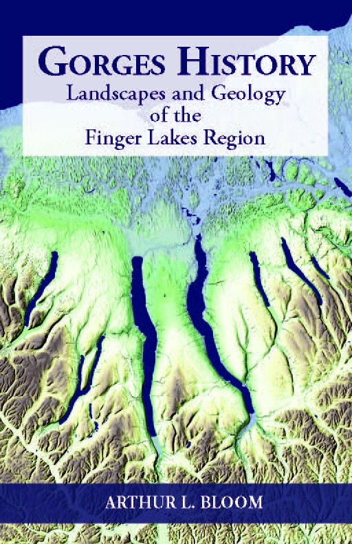
When Art Bloom died a year ago, five of the late geology professor’s colleagues collaborated with his family, local artists and others to finish his book that explains Ithaca and the Finger Lakes scenery. “Gorges History: Landscapes and Geology of the Finger Lakes Region,” was published June 4 by Ithaca’s Paleontological Research Institution.
“Here in the Finger Lakes, there’s a hunger among people that when they see the region’s geology, they want to learn more about it. This book makes the geological details available in an accessible way,” said Matt Pritchard, professor of earth and atmospheric sciences, who marshalled the talents of department colleagues Rick Allmendinger, professor; Rowena Lohman, associate professor; and emeritus professors Daniel E. Karig and Bryan Isacks.
Pritchard will discuss Bloom’s book and the process for completing it at the Cornell Reunion 2018 talk, “Geomorphology of Ithaca and the Finger Lakes Region,” Friday, June 8, at 10:30 a.m. in Room 2146 Snee Hall.
Bloom was known internationally for his pioneering work to establish the history of sea levels during the last 125,000 years. In “Gorges History,” Bloom’s focus is local as he wrote about bent, broken and buckled rock, and how glaciers and water created the Finger Lakes formations. He told the geologic stories of Ludlowville Village Park, Taughannock Falls State Park, Mount Pleasant, Cascadilla Creek, Ellis Hollow and Watkins Glen. As an example, the book details how Fall Creek is the remnant of a once-great river.
“The long, deep Finger Lakes so definitive of the geology of the region are equaled only by the spectacular glacial valleys of alpine regions,” Bloom wrote in his preface. “On the plains of Lake Ontario north of the Finger Lakes, the fields of long, smooth, teardrop-shaped drumlins are similar to only a half-dozen such localities on Earth including Scandinavia, Ireland, central Canada and southern Wisconsin.”
The group used all of Bloom’s text; Allmendinger assembled about a third of the figures, illustrations and maps. “Art had concepts for figures and maps, but he didn’t have time to flesh out the figures,” said Pritchard. “We reinforced his ideas, his visions and the maps that he’d already written about.”
Isacks contributed lidar survey images, which penetrate trees and plants to see Earth formations. “Art would have been delighted to see the color figures in his book,” he said.
Each of the region’s gorges has a unique history, and the book answers questions such as why geologists see rock fractures in Robert H. Treman and Buttermilk Falls state parks, but not at Watkins Glen. Bloom explains why Cayuga and Seneca lakes are larger than the other Finger Lakes.
“Art’s book brings knowledge of the Finger Lakes’ geology into the modern era,” Pritchard said. “If you ever visit Ludlowville Falls, Art freshens our understanding. It’s clear from reading the book that these are reflections from many field trips in many areas, with lots of student interactions and student questions.”
Media Contact
Get Cornell news delivered right to your inbox.
Subscribe