Multiple city hubs, dispersed parks keep metro areas cooler
By James Dean, Cornell Chronicle
Metropolitan areas with multiple city centers and dispersed green spaces mitigate extreme heat more effectively than those with one dominant city, an analysis by Cornell city planning scholars finds.
Compared to “monocentric” development, “polycentric” spatial patterns better distribute the density of urban cores and curb the sprawl of impervious, heat-absorbing surfaces, according to the analysis of 50 city regions in Germany. Particularly in larger urban areas, polycentric development can moderate the urban heat island effect, when built-up areas can be several degrees hotter than surrounding rural areas – a potentially dangerous phenomenon during heat waves that are expected to grow more common due to climate change.
While urban tree canopies and green spaces are known to provide cooling benefits, the researchers also found that that smaller, decentralized open spaces across a metropolitan area are more effective at reducing urban heat compared with a larger, more centralized green space pattern.
The findings suggest cooling strategies that merely address the role of urban density may be insufficient, and point to the need for regional-level planning to coordinate land-use patterns across metropolitan areas.
“More polycentric spatial development, which integrates the benefits of compact and dispersed configurations, can more effectively ameliorate the urban heat island effect,” said Stephan Schmidt, associate professor of city and regional planning in the College of Architecture, Art and Planning. “In addition to other proposed advantages of coordinating regional spatial patterns – such as organizing land-use and transportation networks – mitigating urban heat in a warming world is another benefit.”
Schmidt is a co-author of “Can Spatial Patterns Mitigate the Urban Heat Island Effect? Evidence from German Metropolitan Regions,” published Jan. 18 in the journal Environment and Planning B: Urban Analytics and City Science, with Wenzheng Li, MRP ’18, a doctoral student in the field of city and regional planning.
Planners have debated the relationship between urban density and the heat island effect, with inconclusive results. Denser cites have certain sustainability advantages – shorter travel distances and more efficient use of infrastructure – but studies have suggested they may absorb and hold more heat, and that tall buildings can prevent fresh air from circulating and reducing temperatures. Other studies have found that low-density, fragmented development may exacerbate heating, promoting larger areas of impervious surfaces and higher per capita heat emissions.
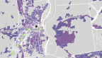
The Cornell team took a broader perspective, investigating the influence of regional spatial patterns in two ways, based on land surface temperatures from 2006 and 2012 satellite data. The first approach utilized landscape metrics developed by wildlife ecologists to measure how fragmented or cohesive natural landscapes are, applying them to urban areas. After controlling for a range of factors, that analysis confirmed that denser (more contiguous) development patterns increased urban heat intensity, and that more dispersed green spaces lowered heat island effects.
“In part this is because multiple smaller green spaces are able to more effectively reduce and break up contiguous urban areas,” Li said. “Deliberate efforts are needed to ensure that dense built-up areas are interspersed with green areas.”
Secondly, the researchers defined a measure of polycentricity for the 50 German city regions, each with a minimum population of 100,000. More polycentric development patterns reduced urban heat during summer months – by 10.3% in the daytime and 25.7% at nighttime with a doubling of the polycentricity index, all else being equal. The benefits were most pronounced in larger metropolitan centers.
Schmidt and Li said the findings have implications for regional-level planning that are already institutionalized in German and European systems that promote polycentric development as a goal. But they said the study can also inform planners and policymakers more broadly to coordinate regional green spaces patterns and to increase the density of suburban nodes.
“There are many other benefits to doing that – limiting sprawl, concentrating population and economic activity, promoting public transit use and increasing affordable housing,” Schmidt said. “And in addition, you’ll have this positive impact on the metropolitan-scale heat island effect.”
The research was supported by the Cornell Sage Fellowship for doctoral students.
Media Contact
Get Cornell news delivered right to your inbox.
Subscribe