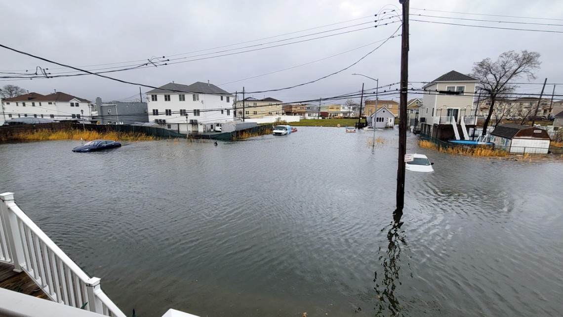
The view from Roger Gendron's front porch, in Hamilton Beach, Queens, after Winter Storm Elliot hit in December 2022. Gendron, president of the New Hamilton Beach Civic Association, has been working with New York Sea Grant for years to document the frequent flooding in his neighborhood.
‘Ground truth’: Flood monitoring tool gives NYS residents a voice
By Caitlin Hayes, Cornell Chronicle
A higher than normal tide first floods the two blocks adjacent to Roger Gendron’s street in Hamilton Beach, Queens. Then it crests the curbs and sidewalks, flows through yards and fills his road, Davenport Court, and stays there. A berm at the end of the street, between the road and Jamaica Bay, traps the water, sometimes through another two or three tide cycles.
“These are the nuances someone like myself and others – we know because it’s our neighborhood,” said Gendron, 63, a lifelong resident of Hamilton Beach, president of the New Hamilton Beach Civic Association and self-taught flood monitor and forecaster for the 450 households in his community. “Nobody knows the neighborhood better.”
In August, the aftereffects of Hurricane Erin brought six inches of flooding to Dune Road in Hampton Bays, New York, part of the service area for Ryan Murphy, public safety and emergency management administrator for the Town of Southampton on Long Island.
But in the past, Gendron’s on-the-ground knowledge didn’t always make it to policymakers, weather forecasters or municipal managers responsible for responding, in real-time and over the long-term, to increasingly intense flooding. New York Sea Grant (NYSG), a cooperative research and extension program housed at Cornell and the State University of New York, has been working for years to change that, by giving New York residents – roughly 90% of whom live along lakes, rivers, streams or the ocean – the tools to understand, document and communicate the flood and storm conditions where they live.
Since 2020, this effort has included the funding, vetting and rollout of the MyCoast New York app, which allows users across the state to upload photos of flood conditions and storm damage that can then be used in storm response and for future planning and forecasting. With funding and partnership from Cornell’s New York State Water Resources Institute (NYSWRI) and the National Sea Grant Office, NYSG began testing and adapting the app, developed by Blue Urchin, for New York, and introduced it to communities in 2022. In the three years since adoption, the data has improved emergency planning and response, educated and empowered communities and has even changed the National Weather Service’s (NWS) approach to forecasting in the Hudson Valley. By 2024, more than 1,800 photos – of both current and historic flooding, storm damage and a changing shoreline – were uploaded from 26 counties.
“The flood risk really is increasing all across the state,” said NYSG’s Jessica Kuonen, Hudson Estuary resilience specialist, who has been leading the rollout of MyCoast. “We’re seeing heavier downpours and bigger storms, we’re seeing places that didn’t used to flood but now are, and people are capturing increased frequency as well. Some of our existing datasets that are used to inform infrastructure or planning don’t always capture this new reality.”
According to the state’s hazard mitigation hub, MitigateNY, $8.5 billion in residential properties could face chronic flooding by 2045, and $95 billion by 2100. MyCoast provides residents with a sense of community and agency, and data they can use to advocate for their needs as risks increase and patterns change.
“MyCoast and ultimately Sea Grant, because they’re the ones behind it, are invaluable,” Gendron said. “Because now I can say: I’m not making it up. It’s not a story. It’s not a fairy tale. In the aftermath of Sandy, it was just us talking. But MyCoast and other tools have given us a way to document. Now it’s a history book that we’re creating.”
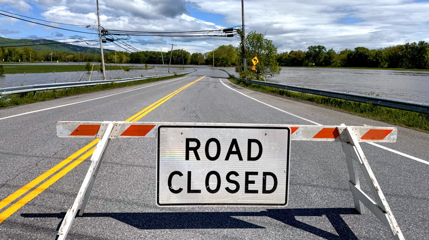
In May, a series of storms caused the flooding of roadways in New Paltz, New York.
Providing ‘ground truth’
In communities along Jamaica Bay, flooding is a regular part of life. Monthly spring tides, tides that occur during full and new moons, routinely push water into roadways, even on sunny days, and storms, increasing in frequency and intensity, more often immobilize neighborhoods. Gendron said residents know where not to park and when to move their cars; they keep sandbags handy and are ready to move items from basements and garages. Many had to rebuild their homes after Hurricane Sandy and live in fear of the next big storm.
NYSG began holding community climate forums in the area in 2016 and found that the main topic was almost always flooding; they formed the Community Flood Watch Program and helped collate photos from community groups and eventually, with partners, shared those images with city officials who were unaware of conditions on the ground. The city took notice, and the New York City Department of Environmental Protection contracted with a new initiative, called FloodNet NYC, to install flood sensors throughout flood-prone areas of the city. FloodNet is a partnership between the City University of New York, New York University, NYSG, city agencies, the mayor’s office and community partners.
“Community science really scored by getting the city to invest in more real-time flood data,” said Kathy Bunting-Howarth, associate director of NYSG. Now, data from FloodNet, 311 calls and MyCoast are used to create reports that residents and city officials can use for planning and mitigation efforts.
But before MyCoast, as FloodNet was getting off the ground, NYSG extension specialists were struggling with a cumbersome platform to compile and process the photos that continued to come in. In 2020, Kuonen, with Kathleen Fallon, NYSG coastal processes and hazards specialist, received grant funding to find an alternative. They vetted MyCoast with a network of other states and organizations, and worked with Blue Urchin to make it useful for inland New Yorkers and to sync uploaded images with data from tidal and river gauges. They also came up with an outreach plan – targeting groups they knew would be interested, from emergency managers to community organizations.
Ryan Murphy, public safety and emergency management administrator for the Town of Southampton on Long Island, was an early adopter. On Aug. 20, as Hurricane Erin threatened to send storm surges along the coast of Long Island and throughout the New York metropolitan area, Murphy was writing a declaration of a state of emergency while monitoring NWS forecasts and the MyCoast webpage, where his staff and citizens were uploading photos of conditions on the ground.
“I’m using it literally right now,” he said. “This is one of those tools that I always have up so we can see what’s coming in and where we’re seeing water and who’s seeing water.”
Murphy said he uses the information in real time to issue appropriate local warnings, communicate conditions to partners at the NWS for broader alerts and to local first responders who may need to perform rescues.
Outside of storms, MyCoast has provided Murphy and his team with data for grant applications; alerted them to broken tidal gauges; and helped them understand baseline conditions, so that they know which roads may flood even when skies are blue.

In 2011, Hurricane Irene flooded the first floor of Roger Gendron’s home in Hamilton Beach, Queens, where rising sea levels and more intense storms cause frequent flooding.
Data from the app has also helped paint a broader picture of how flood patterns are changing. When residents along the Hudson River started uploading photos of flooding to MyCoast during a storm in December 2022, the NWS took notice.
“Before MyCoast, we didn’t have enough data on what was actually occurring to understand there was that much of an impact,” said Nelson Vaz, a warning coordination meteorologist at the NWS of New York.
Forecasters at NWS realized that a storm or higher than normal tide on the coast can cause flooding farther up the river than they realized – and they used that data to revise thresholds for flood warnings. This ultimately improved their ability to alert the public to threats in real-time and also improving future forecasts.
The data has also been used to create impact reports and catalogues that help shape mitigation efforts.
“What MyCoast helps with a lot is the ground truth of what’s happening,” Vaz said.
Empowering residents, building communities
The app’s adoption depends on outreach, and NYSG and NYSWRI have been leveraging existing networks and building new ones as they work around the state to educate, build community and give residents a tool that ultimately gives them a voice.
“I think one of the things that has been really amazing for me is how much it means to people to see their experience get elevated or validated when it becomes a project like this, of really cumulatively describing the impacts of changing environmental processes and of sea-level rise,” said Hannah Burnett, NYSG’s coastal resilience specialist for Jamaica Bay, who runs a Flood Fellows program, a forum for sharing knowledge across neighborhoods, for community leaders. “It’s extremely powerful.”
Kristen Hychka, research and outreach specialist for NYSWRI, has noticed the same thing in her outreach in more inland areas, including Ithaca, where she’s been introducing MyCoast to city officials, municipal workers and community members. She’s also been teaming up with Danielle Eiseman, associate director for the Cornell Health Impacts Core, on an event series that invites area residents to share their flood stories.
“What’s exciting to me about MyCoast is that it’s not only building our database, but it’s engaging people in the process to understand flooding in their communities and how the impacts can lead to ways to mitigate and improve resilience,” Hychka said.
Bringing MyCoast to New York is a project that embodies NYSG’s mission: to build partnerships, though research and education, that ultimately help sustain communities and the environment.
“Sea Grant has been really helpful on both the academic partnership side and the public outreach side,” Vaz said. “They’re always hosting some kind of webinar or in-person meeting that we can jump into and reach different constituencies. This kind of outreach – they’re doing it constantly. It’s a great way to leverage the entire community, and those partnerships have been really effective. It’s been great.”
NYSWRI has funded MyCoast New York through the NYS Department of Environmental Conservation’s Great Lakes Watershed Program and Hudson River Estuary Program, with support from the NYS Environmental Protection Fund. NYSG has also received support for MyCoast from the National Oceanic and Atmospheric Administration, the Long Island Sound Partnership, FEMA Cooperating Technical Partnership and Sea Grant Marine Debris Challenge Grant.
Media Contact
Get Cornell news delivered right to your inbox.
Subscribe