Dreaming of a white New Year's Day? Snowmobile in Caribou, Maine, and Burlington, Vt, or taste wine in upstate New York (News from the northeast regional climate center)
By Blaine Friedlander
At the stroke of year 2000, celebrants throughout the Northeast might be dreaming of a white New Year's Day. Likely their dreams will come true -- if they are in Caribou, Maine, the Finger Lakes region of New York, or Burlington, Vt., according to the Northeast Regional Climate Center at Cornell University.
Most surprising to Keith Eggleston, a senior climatologist at the climate center, is that after Caribou, the second most-likely place to see a white Jan. 1 will be outside his window, in Ithaca N.Y.
"I didn't expect that," says Eggleston. "Ithaca just barely edged out Syracuse. I was surprised to see that. There was one other year, in 1992, where Ithaca had an inch of snow on the ground and Syracuse only had a trace."
While Caribou has a 97 percent chance of having at least one inch of snow on the ground on New Year's Day morning, second-place Ithaca has a 77 percent chance, while Binghamton, N.Y., Syracuse, N.Y., and Burlington, Vt., enjoy a three-way tie at 73 percent. Rochester, N.Y., has a 72 percent chance of a white New Year's Day. And for folks who will cram into Manhattan's Times Square for the big ball drop, the chances of seeing a white Jan. 1 are a lousy 10 percent.
Snowmobile heaven Caribou has seen some major snowfalls on New Year's Day. The Cornell center's climate statistics for the area, which date back to 1939, show that the small Maine town recorded its biggest Jan. 1 snowfall in 1961 with 12.4 inches. Caribou's greatest snow-depth recorded on Jan. 1 was 34 inches in 1979.
Ithaca's heaviest Jan. 1 snowfall also occurred in 1961, when the city saw 11 inches. Ithaca's greatest snow depth on a Jan. 1 was 20 inches in 1970, according to Eggleston. The center's records for the upstate New York region go back to 1929.
Caribou aside, for most of the Northeast, Jan. 1, 1971, was the last great, white New Year's Day. A storm dumped 6.4 inches of snow in New York City, 5 inches in Philadelphia and 4.9 inches in Boston. A New Year's Eve storm on Dec. 31, 1970, dumped 4.4 inches of snow on Washington, D.C., and 4.9 inches the following day. That same storm dropped 3.2 inches of snow on Dec. 31, 1970, in Baltimore and 2.8 inches the next day. A half-century ago, a storm delivered 5.5 inches of snow to New York City on Jan. 1, 1949, according to the center's records.
Why are the chances for snow in central and western New York so great? Eggleston says that it is due to lake-effect snow for cities like Buffalo, Rochester, and Syracuse. He explains that storm systems draw moisture from Lake Erie early in the winter season for Buffalo until the lake freezes. Lake Ontario, a much-larger and deeper lake, produces lake-effect snow throughout the winter for its southern shore, Syracuse and for western Lewis County, N.Y., a region known as the Tug Hill Plateau.
Probability of 1 inch or more of snow on the ground:
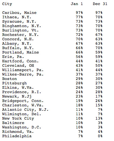
Data compiled by the Northeast Regional Climate Center at Cornell University.
Media Contact
Get Cornell news delivered right to your inbox.
Subscribe