Britney Schmidt and collaborators are publishing two papers in Nature on Feb. 15 related to melting rates, and how melting occurs, at Thwaites Glacier – the hottest glacier in Antarctica.
Underwater robot helps explain Antarctic glacier’s retreat
By James Dean, Cornell Chronicle
First-of-their-kind observations beneath the floating shelf of a vulnerable Antarctic glacier reveal widespread cracks and crevasses where melting occurs more rapidly, contributing to the Florida-sized glacier’s retreat and potentially to sea-level rise, according to a Cornell research team and international collaborators.
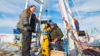
Deploying the remotely operated Icefin underwater robot through a nearly 2,000-foot-deep borehole drilled in the ice, the team captured the first close-up views of the critical point near the grounding line where Thwaites Glacier in western Antarctica – one of the continent’s fastest changing and most unstable glaciers – meets the Amundsen Sea.
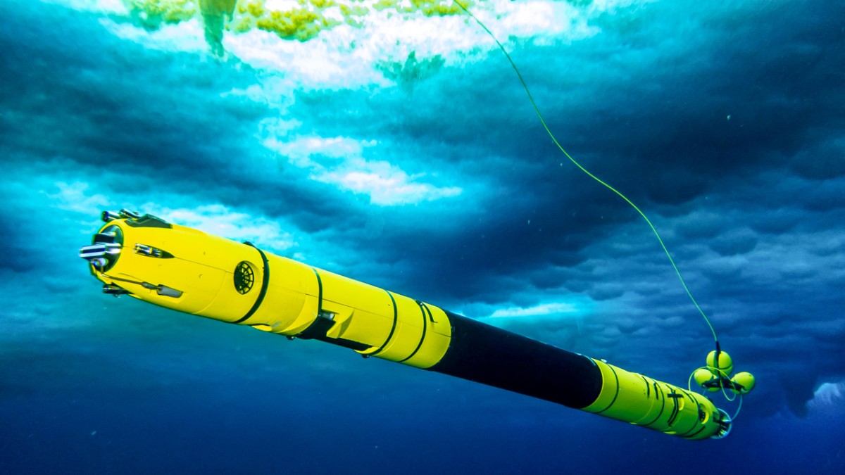
Icefin is a small robotic oceanographer that allows researchers to study ice and water around and beneath ice shelves – and develop the technology to explore other oceans in our solar system.
From that area, the researchers concluded that Thwaites has retreated smoothly and steadily up the ocean floor since at least 2011. They found that flat sections covering much of the ice shelf’s base were thinning, though not as quickly as computer models had suggested. Meanwhile, the walls of steeply sloped crevasses and staircase-like features were melting outward at much faster rates.
The findings, reported Feb. 15 in the journal Nature, provide new insight into melting processes at glaciers exposed to relatively warm ocean water, and promise to improve models predicting Thwaites’ potentially significant contribution to sea-level rise.
“These new ways of observing the glacier allow us to understand that it’s not just how much melting is happening, but how and where it is happening that matters in these very warm parts of Antarctica,” said Britney Schmidt, associate professor of astronomy and earth and atmospheric sciences in the College of Arts and Sciences (A&S) and Cornell Engineering. “We see crevasses, and probably terraces, across warming glaciers like Thwaites. Warm water is getting into the cracks, helping wear down the glacier at its weakest points.”
Schmidt, whose team developed Icefin, is the lead author of “Heterogeneous Melting Near the Thwaites Glacier Grounding Line,” and a co-author of “Suppressed Basal Melting in the Eastern Thwaites Glacier Grounding Zone,” whose first author is Peter Davis, an oceanographer at the British Antarctic Survey (BAS).
Additional co-authors from the Department of Astronomy (A&S) and Schmidt’s Planetary Habitability and Technology Lab include: Research Scientist Peter Washam; Senior Research Engineers Andrew Mullen and Matthew Meister; Research Engineers Frances Bryson ’17 and Daniel Dichek; Program Manager Enrica Quartini; and Justin Lawrence, a former doctoral student and visiting scholar.
“Icefin is collecting data as close to the ice as possible in locations no other tool can currently reach,” said Washam, who led analysis of Icefin data used to calculate melt rates. “It’s showing us that this system is very complex and requires a rethinking of how the ocean is melting the ice, especially in a location like Thwaites.”

Researchers collected the first close-up observations of the grounding line where the remote Thwaites Glacier, one of Antarctica’s fastest changing and most unstable glaciers, meets the Amundsen Sea.
The robotic under-ice observations were collected in early 2020 as part of the International Thwaites Glacier Collaboration (ITGC), the largest international field campaign ever undertaken in Antarctica, funded by the National Science Foundation and the U.K.’s Natural Environment Research Council. Complementing Icefin’s observations, partners on ITGC’s MELT project also collected data using radar, ocean moorings and other sensors at multiple sites.
Since the 1990s, the Thwaites grounding line has retreated nearly 9 miles and the amount of ice flowing out of the 75-mile-wide region has nearly doubled, according to ITGC. Because much of the glacier sits below sea level, it is considered susceptible to rapid ice loss that could raise sea levels by more than 1.5 feet. Collapse of the ice sheet behind Thwaites could add substantially more, “with profound consequences for humanity,” according to BAS.
The BAS team, which used hot water to drill the borehole Icefin accessed about 1 mile from the Thwaites grounding line, reported that over a nine-month period, the ocean in that area became warmer and saltier. Surprisingly, the vertical melt rate over much of the ice was less than previously modeled, averaging 6 feet to 18 feet per year.
“Our results are unexpected, but the glacier is still in trouble,” Davis said. “If an ice shelf and a glacier is in balance, the ice coming off the continent will match the amount of ice being lost through melting and iceberg calving. What we have found is that despite small amounts of melting there is still rapid glacier retreat, so it seems that it doesn’t take a lot to push the glacier out of balance.”
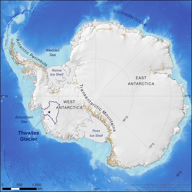
Covering an area larger than Florida or Britain, collapse of the Thwaites Glacier in western Antarctica could contribute significantly to sea-level rise, according to the International Thwaites Glacier Collaboration.
The researchers attributed the varying melt rates in different topography to water stratification and mixing. Along flat sections of ice, a thin layer of melted freshwater acts as a barrier to warmer ocean currents, suppressing upward melting. In contrast, water funneling through sloped crevasses and scalloped terraces transfers heat that promotes faster sideways melting, at estimated rates of up to 140 feet per year.
Schmidt and her team of students and staff, including Meister, Dichek and Lawrence, began developing Icefin nearly a decade ago while at the Georgia Institute of Technology, to explore previously uncharted terrain including grounding lines. Designed to descend through narrow boreholes, the pencil-shaped vehicle – measuring less than 10 inches in diameter and more than 12 feet long – is equipped with thrusters, cameras, mapping instruments and sensors for measuring ocean current speeds, temperature, salinity and oxygen levels – information needed to estimate melt rates.
Icefin’s ongoing development – a fourth-generation vehicle is now under construction – has been supported by NASA. In addition to improving climate models, the space agency believes lessons learned in the Antarctic could inform eventual missions searching for life on the icy moons Europa and Enceladus.
The newly published research also includes co-authors from New York University; New York University Abu Dhabi; Georgia Institute of Technology; Oregon State University; University of Portland; Lewis & Clark College; Pennsylvania State University; University of Kansas; University of California, Irvine; California Institute of Technology; University of Gothenburg in Sweden; and the University of St. Andrews and University of East Anglia in the U.K.
Media Contact
Get Cornell news delivered right to your inbox.
Subscribe