Artificial intelligence may one day give robots social intelligence, but so far, existing models do a poor job of using human facial cues to predict the outcome of a situation.
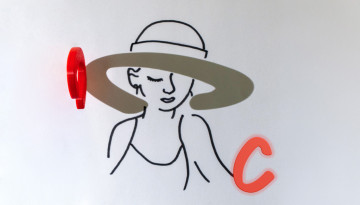
Researchers at Cornell Tech and Cornell Bowers have created an AI framework that can create “shadow art” – partial line drawings that are completed by the shadow cast from an object – by simply scanning the object.
The Cornell Ann S. Bowers College of Computing and Information Science’s celebrated their newest graduates in department recognition ceremonies during Commencement weekend.
The Class of 2026 has the tenacity, talent and determination to advance the unfinished work of American democracy, President Michael I. Kotlikoff told graduates and their guests at Commencement ceremonies held May 23.
A $1.25 million seed grant from James C. Morgan ’60, MBA ’63, and Rebecca Quinn Morgan ’60 will support the establishment of an AI fellows program focused on operational and administrative transformation.