Snow possible this weekend in New York's northern tier and northern New England, Cornell's climate center says
By Blaine Friedlander
New York's northern tier and the northern parts of New England could see snow on Saturday and Sunday. But the wet white stuff may not accumulate enough to qualify as the earliest snow in the region, according to climatologists at Cornell University's Northeast Regional Climate Center (NRCC).
"I wouldn't be surprised to see snow in the air," says Arthur DeGaetano, a senior climatologist at the center. "The surface temperatures will be above freezing for most of weekend. Aloft, however, the air will be cool enough for it to snow, and it won't melt before it hits the ground. It won't last long on the ground."
The Northeast's meteorological snow season started on Oct. 1 and officially won't end until May 31. "I don't think it is that unusual for us to see snow here – after all we're getting into that time of the year when we get traces of snow. For this part of the region, I don't think it's particularly early. Most places north of here have had accumulating snows early," says DeGaetano.
The earliest that Caribou, Maine, saw an appreciable amount of snow was Sept. 29, 1991, when it had 2.1 inches. Syracuse, N.Y., saw an inch of snow on Oct. 2, 1974, while Albany, N.Y., saw an inch of snow on Oct. 4, 1987, and Elkins, W.Va., experienced an inch of snow on Oct. 6, 1932, and on Oct. 6, 1935. But for most places in New York state, the appreciable snows don't start until mid- to late-October.
Keith Eggleston, a senior climatologist with the NRCC, says that southern New England experienced between 2 and 7 inches of snow on Oct. 9-10, 1979 – making for the greatest amount of snow so early in the season for this area. A decade earlier on Oct. 22, 1969, northern New York and northern New England received between three and 12 inches of snow, the biggest accumulation so early in the season for much of this area. This snow was followed by an abnormal, early season cold snap on Oct. 23 and Oct. 24. Patchogue, N.Y., reported a low temperature of 17 degrees on the 24th – the coldest October temperature on record for Long Island.
On Nov. 6, 1953, a surprise nor'easter dumped 5.5 inches of snow on Baltimore and nearly 9 inches on Philadelphia. Washington National Airport in Arlington, Va., had 6.6 inches of snow, while New York City and Newark, N.J., saw more than 2 inches of snow. The nor'easter also pelted central and western New York state with between 10 and 20 inches of snow -- although it was not the earliest, appreciable snowfall that area had seen.
"It was one of the heaviest snowfalls to occur so early in the season for many locations in the Northeast," says Eggleston of the 1953 storm. "The effects of the snow were of little concern, that is with the exception of traffic delays. Real damage was due to flooding along the coast that occurred when the snow melted." Storm damage at the time was estimated at $7.5 million along the coastal sections between New England and New Jersey, he said.
Early Snowfalls for selected Northeast Cities:
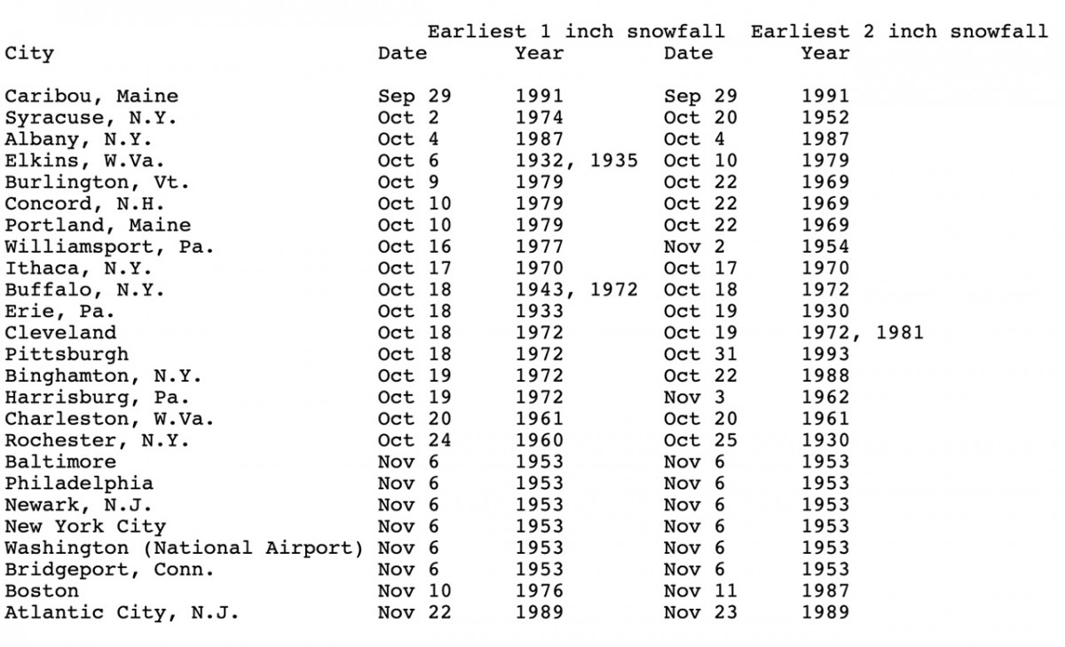
Data compiled by the Northeast Regional Climate Center at Cornell University.
Media Contact
Get Cornell news delivered right to your inbox.
Subscribe