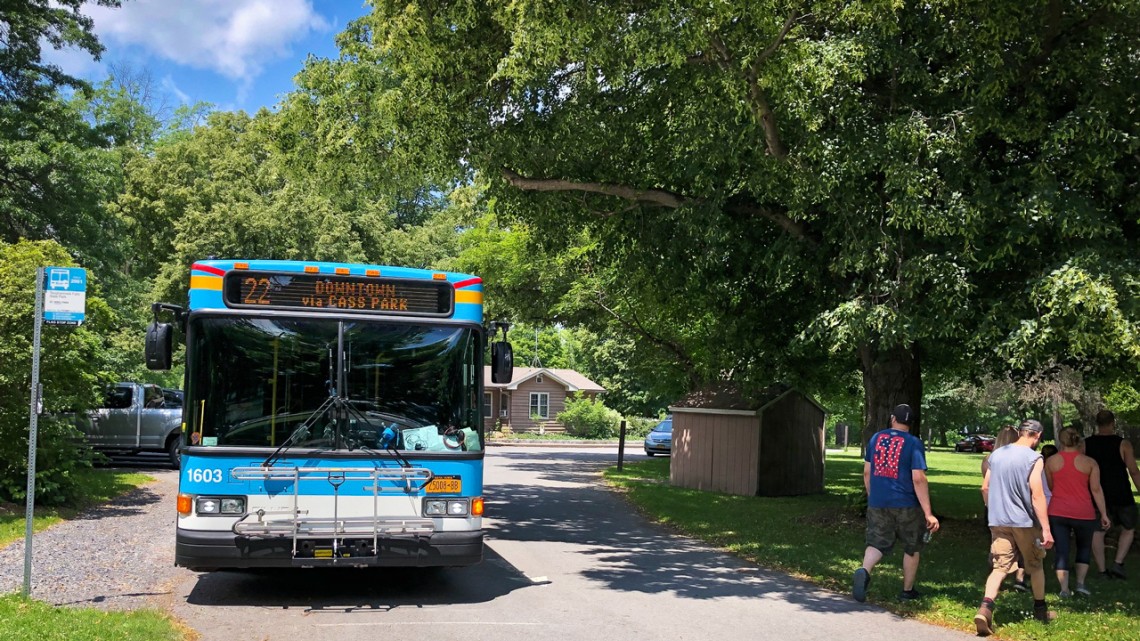
TCAT’s summer route 22 takes hikers to enjoy natural wonder at Taughannock Falls State Park.
Student-designed ‘TCAT to Trails’ map plots path to nature
By Blaine Friedlander
Find tranquility at the base of Buttermilk Falls, gaze across Cayuga Lake from Stewart Park’s willow trees, stroll the waterfront trail to get an apple at the Ithaca Farmers Market.
You can enjoy the area’s trails, natural beauty and autumnal wonder, with no need for a car: Just lace up your hiking boots and leave the driving to the Tompkins Consolidated Area Transit (TCAT) bus system.
Cornell students from the Design Connect team – a group within the College of Architecture, Art and Planning – have researched, designed and prepared the first “TCAT to Trails” map, which debuted in August. It’s a guide to outdoor adventure, via public transit, in Tompkins County.
“It was an idea born of the Cayuga Trails Club, and as a group in the community, we also wanted to improve access to the outdoors. Many people don’t have cars, so getting to parks, trails and waterfalls can be difficult and inequitable,” said Emile Bensedrine ’23, a Design Connect map project co-manager, who worked with project co-manager Quinn Kelly, MRP ’21, to the map’s completion. “It’s an environmental justice issue and we’re addressing it with this new map in a meaningful way.”
The fold-out map is packed with detail. One side shows the parks and natural areas close to Ithaca, explaining the bus stops and connections, while the other side shows links, planning tools, where to find bus schedules and the wider Tompkins County perspective.
For example, the map describes how the Cayuga Waterfront Trail runs from the Tompkins County Chamber of Commerce to Allan H. Treman State Marine Park, then connects to Cass Park and the Farmers Market. TCAT bus routes 13 and 36 can get you close to Stewart Park, while route 13 and 13S can get you to the Farmers Market and GreenStar. Routes 20, 21 and 14 cross Ithaca’s West End.
If you want to walk or bike the East Hill Recreation Way, climb aboard route 51. Taughannock Falls State Park is served by summer route 22, while Robert H. Treman State Park can be reached year round on route 67, via a new bus stop created after discussion between Design Connect and TCAT.
The idea for the map came from the Cayuga Trails Club, where avid hiker Myra Shulman – a retired senior research associate in ecology and evolutionary biology, in the College of Agriculture and Life Sciences – is a board member. Shulman reached out to members of the Cornell Outing Club for help; Kelly and Bensedrine responded, pitched the idea to Matt Yarrow, TCAT’s assistant general manager for service and planning, and the Design Connect TCAT to Trails map project was born.
Design Connect leaders Kelly and Bensedrine enlisted other students, and the group conducted online and in-person ridership surveys last spring. Their data revealed that 44% of TCAT riders neither owned, nor had access to, a car; and two-thirds of the respondents had never taken a TCAT bus to access Tompkins County’s gorges and gorgeous outdoors.
Further, the survey found that “wayfinding” signage – signs that get you from the bus stop to the trail – were either non-existent or unclear. So in addition to creating the map – helped by Yarrow; Patty Poist, communications manager for TCAT; and Jenn Jennings, a TCAT coordinator – the students wrote and developed wayfinding signs for strategic bus stop locations.
Catherine Cullen ’22, who worked primarily on the map design and layout, enjoyed the enthusiasm from TCAT and the Cayuga Trails Club.
“Their passion for the natural environment surrounding Ithaca shone through in their ideas and final product,” she said. “We’re now able to see these maps in circulation and I hope that they inspire people to get out into nature via TCAT bus.”
For Edward Guo ’23, this project was a chance to connect with the surrounding beauty.
“I'm often stuck in the Cornell bubble doing my own work,” he said. “Sometimes I neglect the beautiful environment and neat communities that surround Ithaca. Visiting these places for the project helped me learn more about the characteristics of these places.”
Other map team members include Olivia Gee ’22 and Paine Gronemeyer ’24.
To demonstrate the new map’s efficacy, Bensedrine and Devin Perlo ‘23 led students from the Cornell Outing Club and from the Organization of Urban and Regional Studies earlier this month on a hike through Treman State Park. They arrived via TCAT’s route 20 bus and returned to campus on the route 67 bus.
“It was rewarding,” Perlo said, “to see our suggestions implemented on official TCAT maps and schedules, and to be able to use the map firsthand.”
Design Connect is a student-run organization and a workshop in the Department of City and Regional Planning that provides course credit and mentorship to students engaged in the group’s projects.
Get Cornell news delivered right to your inbox.
Subscribe