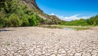
Water levels have dropped so much at the Lake Mead reservoir, on the Nevada-Arizona border, that water Intake No. 1 is now exposed above the lake's surface in this April 25 photo.
Western municipal water restraints rise as reservoirs fall
By Blaine Friedlander
As water restrictions tighten in Southern California in anticipation of summer, the Southwestern United States is seeing growing evidence of climate change and drought for millions of western residents, according to a Cornell expert in the Department of Earth and Atmospheric Sciences.
For the first time in the 87-year history of the reservoir Lake Mead, the Southern Nevada Water Authority that serves Southern California, Arizona, New Mexico and Nevada with water, announced April 1 that the relatively new Low Lake Level Pumping Station – taking in drinking water from deep within the lake – has joined Intake No. 3 to supplying water for the region. Intake No. 1 and Intake No. 2 have been closed, due to a low reservoir.
Flavio Lehner, assistant professor in the College of Agriculture and Life Sciences, said that both the Lake Mead and Lake Powell reservoirs had robust water availability in 1980s and around the year 2000. But now, both reservoirs combined are down to the equivalent of one year’s worth of natural streamflow.
“That doesn’t mean we’re running out of water in one year, because the Colorado River is not completely dry by any means,” Lehner said. “It just means that current supply is not keeping up with demand.”
With the current level of water-usage behavior, Lehner said, the river will provide several decades of water. “But fundamentally, we’re clearly overdrawing the system,” he said. “We do, however, have less than a one-year buffer in our reservoirs when we look at how much water usually comes down the Colorado River in a year.”
Hundreds of miles up the Colorado River from Lake Mead is Lees Ferry, Arizona, a consistent river gauge station. The naturalized flow of the river has waned substantially, according to Lehner. Before the water reaches Lake Powell and Lake Meade, humans are taking water from the river in various ways.
When Hoover Dam (which created Lake Mead) was built in the 1930s, scientists expected the Colorado River to produce 16.4 million acre-feet per year – an ample amount of water. Now, the river is about 63% of that topped-out flow from 1922 (when seven states entered the Colorado River Compact) and will provide only about 10 million acre-feet by the end of this water year, according to Lehner, based on the U.S. Bureau of Reclamation predictions.
Lehner has been maintaining a hydrologic watch over the Southwest U.S. for about a decade. In March, he published two papers outlining how a climate-changing Earth is transitioning toward more frequent and deeper droughts. The first paper, “Twenty-First Century Hydroclimate: A Continually Changing Baseline, With More Frequent Extremes,” published March 14 in the Proceedings of the National Academy of Sciences. The second paper, “Precipitation Trends Determine Future Occurrences of Compound Hot–Dry Events,” published March 14 in Nature Climate Change.
“What you’re seeing in the Colorado River is that we are having a long term, slow and gradual change in our climate,” Lehner said. “The river responds to rising temperatures, changes in precipitation, and other factors with an enduring decline in flow and increasingly frequent drought conditions.
“These long-term trends are hard to reverse,” he said. “Thus, water resource planning for the future might need to include the possibility of continuing low flows.”
Media Contact
Get Cornell news delivered right to your inbox.
Subscribe