The remnants of Hurricane Ida left cars submerged on flooded roads in New Brunswick, New Jersey.
Ida’s remnants struck idling front for historic deluge
By Blaine Friedlander
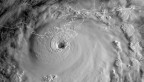
Packed with an historically massive amount of tropical water, the remnants from Category 4 Hurricane Ida deluged eastern Pennsylvania, New Jersey and New York City with unmatched rainfall on Sept. 1.
The storm prompted rivers and creeks to overflow, spawned tornadoes, and qualified as exceeding 500-year and 1,000-year rainfall events, according to Cornell’s NOAA Northeast Regional Climate Center (NRCC), in the College of Agriculture and Life Sciences.
“The rainfall from Ida resulted from the merger of the remnants of Hurricane Ida (a tropical depression when it reached the Northeast) and a stationary front that was draped across New Jersey,” said Arthur T. DeGaetano, professor of earth and atmospheric sciences (CALS) and director of the NRCC.
Since 1983, Cornell’s NRCC has been collecting and archiving climate data to assess weather impacts in the Northeast. In addition to temperature and precipitation statistics, the group examines climatic variables for agricultural production, hydrology and environmental impacts.
“What had been the center of Ida, tracked over parts of Pennsylvania, New Jersey, New York and Connecticut, which received the heaviest rainfall totals,” DeGaetano said. “Such interactions between hurricane remnants and mid-latitude frontal boundaries, commonly produce heavy rainfall, as the very moist tropical air associated with the hurricane is forced to rise over cooler air associated with the frontal boundary.
“This is a very effective mechanism to transform the water vapor in the atmosphere into rainfall,” he said.
On Sept. 1, Central Park in New York City, received 3.15 inches of rain as it fell from about 9 to about 10 p.m., their all-time rainiest hour, according to NRCC climatologist Samantha Borisoff, who compiled the climate data after the massive storm. Central Park’s two-hour rainfall of 4.65 inches and the six-hour of 6.63 inches both were 500-year storm events
LaGuardia Airport, in Queens, saw 6.8 inches of rain on Sept. 1, its all-time wettest day, she said.
“While the total daily rainfall associated with Ida was not a big surprise, the rate at which it fell in a very short one- to six-hour period was astonishing,” DeGaetano said.
“Records show the previous long-held hourly precipitation record at Central Park, of 2.83 inches, occurred on Aug. 26, 1947, in association with a strong frontal system that crossed the region,” he said. “Receiving over 3 inches of rainfall in an hour was indeed surprising, especially after receiving nearly 2 inches in an hour a week earlier.”
Since the rain presented an imminent and significant threat to human life or property, flash flood emergency warnings were issued for the first time in New York City and northern New Jersey, Borisoff said.
West of the city, across the Hudson River, Newark, New Jersey saw its all-time rainiest day with a total of 8.41 inches on Sept. 1, which – on the month’s first day – made it the fourth wettest September on record.
Newark’s wettest hour, with 3.24 inches from 8 to 9 p.m. on Sept. 1, was a 500-year storm event, while its 5.06 inches in two hours and 7.88 inches in six hours, on the same day, were also at least 500-year events, Borisoff said.
In a three-hour period, Newark saw 6.42 inches during the tempest, as that is estimated to be near the storm’s sole 1,000-year event.
The center noted that the normally tranquil Brandywine Creek at Chadds Ford, Pennsylvania, reached 21.04 feet, it’s all-time highest water level on record – as measurements go back well over 100 years. Brandywine Creek’s previous crest record was 17.15 feet on Sept. 17, 1999.
Borisoff reported that the storm spawned at least 11 tornadoes, with the most in Pennsylvania. An Enhanced Fujita Scale 3 (EF-3) tornado was spotted Sept. 1 in southern New Jersey, with winds up to 150 mph, and cut a 12.6-mile swath. EF-2 tornadoes were spotted in Montgomery County, Pennsylvania and Annapolis, Maryland.
“These high rainfall totals – in line with increases in rainfall intensity – are expected,” said DeGaetano, a fellow at Cornell Atkinson Center for Sustainability, “as the oceans and atmosphere continue to warm from greenhouse gas emissions.”
Media Contact
Get Cornell news delivered right to your inbox.
Subscribe